La presse électronique nationale s’est fait l’écho dernièrement de la tentative de blocage par l’ANCFCC du réseau GNSS de stations permanentes ITRI, promu par un IGT du secteur Privé. L’IGT a porté l’affaire devant le tribunal administratif de Rabat.
Dans la lignée de mes blogs où j’avais fais allusion à cette affaire, je vais dans ce qui suit faire état de bonnes pratiques qui ont ont permis à des pays de voir naître des partenariats entre les secteurs public privé et académique dan ce domaine, facilitant l’innovation, les investissements et par conséquent la densification du réseau.
Le partenariat comme bonne pratique
L’absence de concertation sur de question importantes a toujours été source de problème entre l’ANCFCC et le secteur Topographique privé.
Un antécédent en 2013, concernant les prises de vues aériennes dans le pays.

Spatial Data Infrastructures (SDIs) at the national level (NSDIs) are the guiding policies, networks, and standards that enable the exchange, dissemination, interoperability, and use of essential spatial data by governmental, citizen, private sector, and other actors (Crompvoets et al., 2018; Masser, 2019). Since its first use in the mid-1990s, the term and concept have adapted and expanded as technologies, capabilities, and societal demands changed. The IGIF, endorsed by the uN-GGIM, provides global policy guidance for implementing NSDIs (uN-GGIM, 2019). SDIs can also be conceived at supranational levels, as exemplified by the european Commission’s INSPIRe3 directive, and at local government or enterprise levels. There is a close relationship between NSDIs and land administration. Land administration may directly use NSDIs to support service delivery.
NSDIs rely on land administration to provide fundamental NSDI datasets and standards.
https://www.fig.net/resources/publications/figpub/pub80/figpub80.asp
Pathway 7 – partnerships – aims to establish effective cross-sector and interdisciplinary
cooperation, industry and private sector partnerships, and international cooperation.
Pathway 8 – capacity and education – ensures that geospatial information management and entrepreneurship can be sustained in the longer term by capacity building and education. Pathway 9 – communication and engagement – recognizes that stakeholders (including the general community) are integral to the implementation of integrated geospatial information management systems and that their buy-in and commitment is critical to success.
https://www.fig.net/resources/publications/figpub/pub78/figpub78.asp
Architecture hiérarchique des Réseaux GNSS
Les exemples de partenariats Public-Privé dans la réalisation de réseaux GNSS CORS ont déjà été présentés.
Derrière la réussite des ces modèle de coopération, la disponibilité de Guides, Lignes directrices, Normes et bonnes pratiques à l’échelle internationale.
Au niveau international-FIG
While the CORS networks described above are operated by authorities of different level and/or scientific institutions, there is a large number of private networks providing access to correction data by subscription. In many cases such networks are deployed by the major GNSS equipment manufacturers to provide comprehensive solutions for high-precision PNT to their customers.
ttps://www.fig.net/resources/publications/figpub/pub74/Figpub74.pdf
Au niveau d’un pays -Australie
A titre d’exemple , l’architecture à trois niveaux adoptés par ICSM en Australie, permet de clarifier ainsi les rôles du secteur public et celui des secteurs privés.
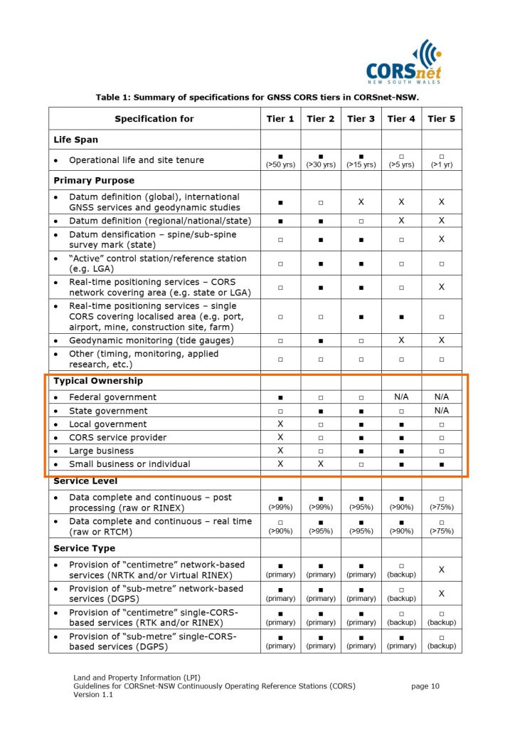
Rizos (2007) introduced the concept of a tiered approach to GNSS CORS. The first three tiers are described as follows:
– Tier 1: the International GNSS Service1 (IGS) stations or equivalent, that is those GNSS CORS contributing to the development of the International Terrestrial Reference Frame for the globe or region;
– Tier 2: the primary national geodetic network or the backbone of a national geospatial reference system and frame or datum;
– Tier 3: the state (or secondary) and private GNSS networks, which primarily provide access to and realisation of the datum through positioning services
https://icsm.gov.au/sites/default/files/2018-02/Guideline-for-Continuously-Operating-Reference-Stations_v2.1.pdf
Au niveau d’une région – NSW Australie
Based on the current status of GNSS technology, indicative inter-station distances of GNSS CORS are as follows:
Tier 1 GNSS CORS should have a typical inter-station distance of between 500 and 1500 kilometres or less.
Tier 2 GNSS CORS should have a typical inter-station distance of between 90 and 500 kilometres or less.
Tier 3 and Tier 4 GNSS CORS should have a typical inter-station distance of between 20 and 90 kilometres or less.
Tier 5 GNSS CORS are established on an opportunity basis, either as an autonomous (standalone) CORS located central to the intended area of operation or as a cluster of several CORS. A suggested inter-station
distance is therefore not applicable.
https://www.spatial.nsw.gov.au/__data/assets/pdf_file/0003/160707/Guidelines_for_CORSnet-NSW_CORS_v1.1.pdf
Une nécessité : Inclusion et Concertation
Le chantier de la stratégie foncière nationale mené en partenariat par l’ANCFCC et MCA_Morocco, notamment dans son pilier Système d’information du Cadastre économique multi-usages, offre une opportunité pour remettre sur de bonnes bases, la concertation entre toutes les parties prenantes: secteur Public, secteur privé , académie et société civile, et ce dans une optique de partenariat Gagnant-Gagnant.
Ceci aura certainement des répercussions sur les autres domaines tels que les réseaux GNSS de stations permanentes, dans lequel le Secteur Topographique Privé, est un acteur majeur de part la loi 30_93.