


Dans le précédent billet, nous avons abordé la souveraineté algorithmique, et montré que le développement de solutions GeoAI locales restent incomplets sans la maîtrise de la couche fondamentale de toutes les données géographiques : le système de référence géodésique.
Sans infrastructure géodésique fiable, précise et souveraine, il n’y a ni administration foncière numérique crédible , ni cadastre moderne, ni agriculture de précision, ni modélisation climatique robuste. C’est le socle de base de l’infrastructure géospatiale.
Contexte stratégique: un double déficit
Le WGIC Horizons 2026 a confirmé que le géospatial est désormais une couche stratégique des politiques publiques: infrastructures, résilience, climat, mobilité, énergie, IA et confiance citoyenne.
Dans ce contexte, le rapport UKRI/STFC GGOS Africa (2026) fournit la première évaluation continentale de la géodésie africaine : un diagnostic essentiel pour repositionner (African Geodetic Reference Frame) comme pilier de la souveraineté géospatiale.
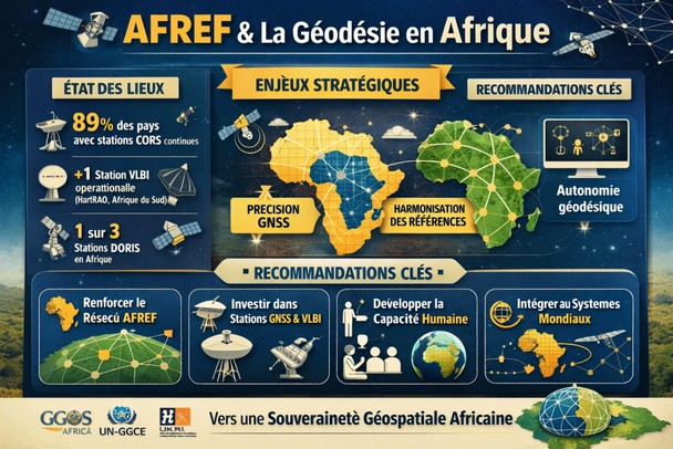
Le rapport Assessment of Geodetic Infrastructure and Human Capital Development in Africa révèle un double déficit majeur sur le continent :
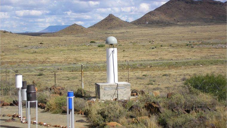
- Déficit infrastructurel : nombre très insuffisant de stations CORS permanentes de haute qualité intégrées au projet AFREF.
- Déficit en capital humain : pénurie chronique de géodésiens hautement qualifiés, d’ingénieurs en géodésie spatiale et de techniciens capables d’assurer la maintenance et l’évolution de ces infrastructures critiques.
Ces lacunes maintiennent le continent dans une dépendance vis à vis des repères produits hors d’Afrique, limitant l’interopérabilité et la précision des systèmes nationaux.
De l’observateur au contributeur
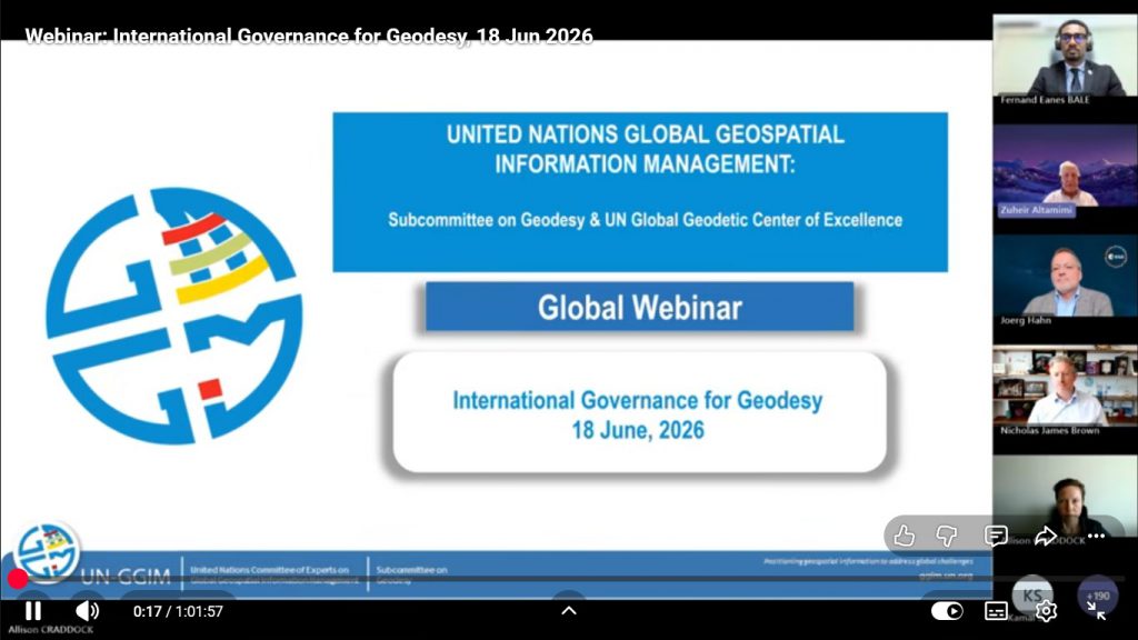
Le webinaire international de l’UN-GGCE (18 juin 2026) sur la gouvernance de la géodésie a confirmé ces constats : la gouvernance mondiale de la géodésie reste fragmentée et insuffisante.
Face à ce vide, l’Afrique a une opportunité historique de passer d’observateur à contributeur actif.
Le webinaire UN-GGCE (18 juin 2026) et le rapport GGOS-Africa convergent: l’Afrique doit passer du rôle d’observateur à celui de contributeur actif à la Chaîne Globale de Géodésie.
Cela suppose:
- Une AFREF robuste intégrée aux réseaux mondiaux (ITRF, GGOS).
- Une harmonisation des systèmes de référence pour réduire les coûts et renforcer la cohérence transfrontalière.
- Une autonomie algorithmique dans la production de données géodésiques.
AFREF doit devenir un projet continental stratégique
L’AFREF n’est pas un projet technique réservé aux spécialistes. Il constitue l’infrastructure invisible sur laquelle repose toute l’intelligence spatiale africaine. Une AFREF robuste permettrait à l’Afrique de :
- Améliorer significativement la précision des services GNSS sur le continent ;
- Renforcer sa contribution à la Chaîne Globale de Géodésie (Global Geodesy Supply Chain) ;
- Gagner en autonomie dans la production de données géodésiques de référence.
https://www.youtube.com/watch?v=NOElsmtVkZE
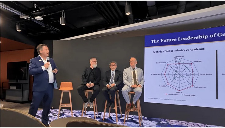
Capital humain et leadership
Le WGIC Horizons 2026 a mis en avant le Doctorat exécutif en leadership géospatial (DGEO), modèle inspirant pour l’Afrique.
Lancer un Plan d’Urgence Capital Humain aligné sur les recommandations du rapport:
- Développer et s’ils existent renforcer les programmes de Master et Doctorat en géodésie appliquée et spatiale.
- Former aux techniques avancées: GNSS, géoïde, VLBI, DORIS, modélisation de référence.
- Mobiliser les pôles d’excellence africains et le UN-GGCE pour le transfert de savoir faire.
https://wgicouncil.org/executive-doctor-geospatial-leadership-wgic-clark-usc/
Recommandations pour la 12ième Réunion UN-GGIM: Africa
La 58ième Session de la Conférence des Ministres africains des Finances, de la Planification et du Développement Économique (Tanger, avril 2026) a clairement positionné les infrastructures numériques et l’innovation technologique comme piliers de la transformation structurelle du continent. Dans ce contexte, l’AFREF ne peut plus être considéré comme un projet technique isolé, mais comme une infrastructure critique et fondatrice de la souveraineté numérique africaine. Sans référence géodésique précise et souveraine, les ambitions exprimées à Tanger en matière de centres de données, d’IA et d’économie numérique risquent de rester limitées.
- Élever l’AFREF au rang de projet phare continental avec une gouvernance politique dédiée.
- Investir dans les infrastructures GNSS et les techniques géodésiques avancées et développer des modèles de financement innovants : intégrer les stations géodésiques dans les grands projets d’infrastructure nationale et recourir massivement aux PPP.
- Renforcer la collaboration avec le UN Global Geodetic Centre of Excellence pour accélérer le transfert de technologies et de savoir-faire.
- Harmoniser les cadres de référence et intégrer la géodésie dans la planification du développement (Agenda 2063).
- Institutionnaliser la coopération avec le UN-GGCE et les partenaires du projet GGOS-Africa.
- Lancer un Plan d’Urgence Capital Humain : création/renforcement de programmes régionaux de formation en géodésie appliquée et spatiale, en partenariat avec les pays leaders.
- Créer un réseau africain de leadership géospatial, inspiré du modèle DGEO.
L’Afrique ne pourra revendiquer une véritable souveraineté géospatiale et algorithmique tant qu’elle restera dépendante des infrastructures de référence produites ailleurs.
Conclusion
L’Afrique dispose désormais d’un diagnostic clair et d’une feuille de route pour bâtir sa souveraineté géospatiale.
Le moment est venu de “voir l’Afrique clairement” — non seulement sur les cartes, mais dans la chaîne mondiale de la géodésie, en tant qu’acteur stratégique du futur géospatial global.
Références
https://zenodo.org/records/20551290
https://ggim.un.org/UNGGCE/documents/CDWA/1/1_3_2%20-%20History%20of%20AFREF.pdf
https://wgicouncil.org/wgic-horizons-2026-geospatial-digital-infrastructure/
https://iav.ac.ma/sites/default/files/2020-06/Master-GNSS_FSGIT-IAV-H2.pdf
https://www.gim-international.com/content/article/development-between-2000-and-2015
Prochain billet : Nous présenterons l’African Geospatial Development Index (AGDI), l’outil continental indispensable pour mesurer, suivre et piloter cette transformation stratégique.
AFREF and the Global Geodesy Supply Chain: How Africa Can Strengthen Its Strategic Role
In our previous post, we demonstrated that algorithmic sovereignty and the development of local GeoAI solutions remain incomplete without mastering the foundational layer of all geographic data: the geodetic reference frame.
Without a reliable, precise, and sovereign geodetic infrastructure, there can be no modern land administration, no precision agriculture, no robust climate modeling, and no credible digital land registries. Geospatial intelligence begins here.
Strategic Context: A Double Deficit
The WGIC Horizons 2026 report confirmed that geospatial technology is now a strategic layer of public policy, impacting infrastructure, resilience, climate, mobility, energy, AI, and citizen trust. In this context, the UKRI/STFC GGOS Africa (2026) report provides the first continental assessment of African geodesy. This diagnostic is essential for repositioning AFREF (African Geodetic Reference Frame) as a pillar of geospatial sovereignty.
The findings of the report, titled Assessment of Geodetic Infrastructure and Human Capital Development in Africa, reveal a critical double deficit across the continent:
- Infrastructural Deficit: Although 89% of African countries have CORS stations, coverage remains highly uneven. High-quality permanent stations integrated into the AFREF project are insufficient, and participation in global networks (such as VLBI and DORIS) remains marginal.
- Human Capital Deficit: There is a chronic shortage of highly qualified geodesists, space geodesy engineers, and technicians capable of maintaining and evolving these critical infrastructures. Most training is limited to undergraduate levels, with very few specialized programs in space geodesy or geoid modeling.
This structural weakness leaves Africa as a permanent consumer of geodetic products managed and controlled primarily outside the continent, limiting the interoperability and accuracy of national systems.
From Observer to Active Contributor
The UN-GGCE international webinar on geodesy governance (June 18, 2026) and the GGOS-Africa report converge on a single conclusion: global geodesy governance remains fragmented. This vacuum presents a historic opportunity for Africa to transition from a passive observer to an active contributor to the Global Geodesy Supply Chain.
Achieving this requires:
- A robust AFREF integrated into global networks (ITRF, GGOS).
- Harmonized reference systems to reduce costs and enhance cross-border consistency.
- Algorithmic autonomy in generating reference geodetic data.
AFREF is not just a technical project for specialists; it is the invisible infrastructure underpinning all African spatial intelligence.
Actionable Recommendations for the 12th UN-GGIM: Africa Meeting
The 58th Session of the Conference of African Ministers of Finance, Planning and Economic Development (Tangier, April 2026) clearly positioned digital infrastructure and technological innovation as pillars of the continent’s structural transformation. In this context, the AFREF (African Regional Fund for Economic and Social Development) can no longer be considered an isolated technical project, but rather a critical and foundational infrastructure for African digital sovereignty. Without a precise and sovereign geodetic reference point, the ambitions expressed in Tangier regarding data centers, AI, and the digital economy risk remaining limited.
- Political Governance: Elevate AFREF to a flagship continental project with dedicated political leadership, integrating geodesy directly into national development planning and the AU Agenda 2063.
- Infrastructure & Financing: Invest in advanced GNSS and geodetic techniques. Develop innovative financing models by embedding geodetic stations into major national infrastructure projects and leveraging Public-Private Partnerships (PPPs).
- Institutional Partnerships: Institutionalize collaboration with the UN Global Geodetic Centre of Excellence (UN-GGCE) and GGOS-Africa partners to accelerate technology and knowledge transfer.
- Human Capital Emergency Plan: Launch/strengthening regional programs in applied and space geodesy (GNSS, geoid, VLBI, DORIS) in partnership with leading nations.
- Geospatial Leadership: Create an African geospatial leadership network inspired by the Executive Doctorate in Geospatial Leadership (DGEO) model highlighted at WGIC Horizons 2026.
Conclusion
Africa cannot claim true geospatial and algorithmic sovereignty while remaining dependent on reference infrastructures produced elsewhere. The continent now has a clear diagnostic and a roadmap. The time has come to « see Africa clearly »—not just on maps, but as a strategic actor within the global geodesy supply chain.
References & Links:
- GGOS Africa Report – Zenodo
- https://ggim.un.org/UNGGCE/documents/CDWA/1/1_3_2%20-%20History%20of%20AFREF.pdf
- WGIC Horizons 2026
- WGIC Executive Doctor in Geospatial Leadership
- https://iav.ac.ma/sites/default/files/2020-06/Master-GNSS_FSGIT-IAV-H2.pdf
Next Post: We will introduce the African Geospatial Development Index (AGDI), the indispensable continental tool to measure, monitor, and drive this strategic transformation.